Drone aerial mapping can be a valuable tool for conducting house census due to its ability to efficiently capture detailed aerial imagery of large areas. Here’s how it can help:
1. Comprehensive Coverage: Drones equipped with high-resolution cameras can capture detailed imagery of entire neighborhoods or regions in a relatively short amount of time. This allows for comprehensive coverage of the area, ensuring that all houses are included in the census.
2. Detailed Imagery: Aerial imagery captured by drones provides detailed information about the houses, including their location, size, and condition. This information can be used to verify the existence of houses, assess their structural integrity, and identify any changes or developments since the last census.
3. Efficiency: Traditional methods of conducting house census, such as door-to-door surveys, can be time-consuming and resource-intensive. Drone aerial mapping offers a more efficient alternative by enabling data collection from above, eliminating the need for manual ground surveys.
4. Remote Accessibility: Drones can access areas that may be difficult or dangerous for surveyors to reach on foot, such as remote or inaccessible locations. This ensures that even houses in remote or rugged terrain can be included in the census.
5. Data Accuracy: Aerial imagery captured by drones provides highly accurate data, allowing for precise location and property boundary delineation. This helps to minimize errors and discrepancies in the census data.
6. Timeliness: Drone aerial mapping can be conducted rapidly, allowing for timely data collection and analysis. This is particularly important for conducting frequent or periodic house censuses to track population changes and urban development.
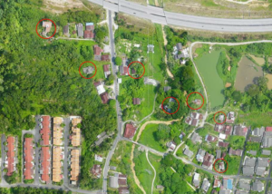
In the figure, the red circle indicates some houses that are difficult to reach if doing the census by walking
Overall, drone aerial mapping offers a cost-effective, efficient, and accurate solution for conducting house census, providing valuable data for urban planning, infrastructure development, and public policy decision-making. Dont forget to contact MySpatial today; +60133565626 or [email protected] to learn more about aerial mapping and how it can benefit your life . Let’s embark on a journey of innovation and exploration together !!