Drones can play a significant role in designing new plantations on farms by providing valuable data and insights throughout the planning process. Here’s how drones can help:
- Aerial Surveying and Mapping: Drones equipped with cameras or multispectral sensors can capture high-resolution aerial imagery of the farm area. This imagery can be used to create detailed maps and 3D models of the terrain, allowing farmers to assess factors such as soil composition, topography, drainage patterns, and existing vegetation cover. This information is crucial for identifying suitable locations for new plantations and optimizing the layout of crops.
- Site Selection and Planning: By analyzing the aerial imagery and terrain data collected by drones, farmers can identify optimal sites for new plantations based on factors such as soil fertility, sunlight exposure, water availability, and proximity to existing infrastructure. Drones can help farmers make informed decisions about crop selection, planting density, and the layout of rows or beds within the plantation area.
- Precision Farming Practices: Drones equipped with specialized sensors, such as multispectral or thermal cameras, can provide valuable insights into crop health and vigor. By collecting data on factors such as plant health, nutrient levels, water stress, and pest infestations, drones can help farmers identify areas of the farm that may require special attention or management practices. This information enables farmers to implement precision farming techniques, such as variable rate fertilization or targeted pest control, to optimize crop yields and minimize input costs.
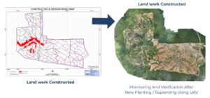
- Monitoring and Management: Once new plantations are established, drones can be used for ongoing monitoring and management activities. Drones can regularly survey the plantation area to monitor crop growth, detect signs of stress or disease, assess the effectiveness of irrigation systems, and identify areas of the farm that may require intervention. This real-time monitoring allows farmers to make timely adjustments to their management practices and ensure the health and productivity of their crops.
Overall, drones offer a powerful tool for designing and managing new plantations on farms, providing farmers with valuable data and insights that can inform decision-making and improve overall productivity and sustainability.
Transform your farm with precision and expertise! Contact MySpatial today; +60133565626 or [email protected] to get a tailored quotation for our comprehensive plantation design services today. From aerial surveying to crop selection and layout planning, we’ll help you maximize yield and efficiency. Let’s cultivate success together! 🌾