In today’s fast-paced world, the ability to gather accurate and detailed spatial data is more critical than ever. Aerial mapping, also known as aerial surveying or photogrammetry, plays a crucial role in this process, offering valuable insights and opportunities across a wide range of industries and applications. Let’s explore why aerial mapping is so important and how it’s shaping the future of data-driven decision-making.
Accurate and Comprehensive Data: Aerial mapping allows for the collection of accurate and comprehensive spatial data over large areas in a relatively short amount of time. By utilizing high-resolution imagery, LiDAR technology, and other advanced sensors mounted on aircraft or drones, aerial mapping provides detailed information about terrain, infrastructure, vegetation, and more. This data serves as the foundation for various applications, from urban planning and environmental monitoring to disaster response and infrastructure development.
Efficient Data Collection: Compared to traditional ground-based surveys, aerial mapping offers significant advantages in terms of efficiency and cost-effectiveness. With the ability to cover large areas quickly and capture data from difficult-to-reach locations, aerial mapping reduces the time and resources required for data collection. This enables organizations to gather timely and accurate information for decision-making purposes, leading to more informed and effective outcomes.
Improved Planning and Decision-Making: Aerial mapping provides decision-makers with valuable insights into spatial patterns, trends, and relationships that are not always apparent from ground-level perspectives. By analyzing aerial imagery and 3D models generated from mapping data, planners, engineers, and policymakers can better understand the spatial context of their projects and make more informed decisions. Whether it’s optimizing land use, designing transportation networks, or assessing environmental impacts, aerial mapping enhances the planning process and helps stakeholders visualize the potential outcomes of their actions.
Enhanced Safety and Risk Management: In industries such as construction, mining, and infrastructure management, aerial mapping plays a crucial role in safety and risk management. By identifying potential hazards, monitoring changes in the landscape, and assessing the condition of assets from above, aerial mapping helps organizations mitigate risks, prevent accidents, and ensure compliance with safety regulations. This proactive approach to safety not only protects workers and the public but also minimizes downtime and costly disruptions to operations.
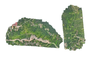
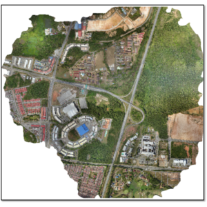
The following figure shows an example of aerial mapping results
In conclusion, aerial mapping is a powerful tool that offers a wealth of benefits across various industries and applications. As technology continues to advance and new applications emerge, the importance of aerial mapping will only continue to grow, shaping the future of data-driven decision-making and spatial analysis.
Dont forget to contact MySpatial today; +60133565626 or [email protected] to learn more about aerial mapping and how it can benefit your life . Let’s embark on a journey of innovation and exploration together!